Geology: Difference between revisions
No edit summary |
|||
| Line 2: | Line 2: | ||
== | ==Geology of Africa== | ||
A new geology map of Africa is presented in this Atlas, based on the USGS 1:5 million scale map of geology, oil and gas fields and geologic provinces of Africa (Persits et al., 2002). The USGS map is itself based on the 1:5 million scale geological map published in 1964 by UNESCO. | |||
The new geology map of Africa presented here has been modified by the British Geological Survey to group or subdivide selected geological units, or to reveal bedrock geology below unconsolidated deposits, in order to better reflect significant hydrogeological differences (MacDonald et al., 2012). The following key modifications have been made: | |||
'''Precambrian rocks''' have in most cases been subdivided into three: | '''Precambrian rocks''' have in most cases been subdivided into three: | ||
| Line 19: | Line 21: | ||
<div><ul> | <div><ul> | ||
<li style="display: inline-block;"> [[File:Geology.png | 400px| left| Geology of Africa, 1:5 million scale | <li style="display: inline-block;"> [[File:Geology.png | 400px| left| Geology of Africa, 1:5 million scale. From USGS (Persits et al. 2002).]] </li> | ||
<li style="display: inline-block;"> [[File:Geology_Key.png | 400px |right | Legend for geology map of Africa, 1:5 million scale | <li style="display: inline-block;"> [[File:Geology_Key.png | 400px |right | Legend for geology map of Africa, 1:5 million scale. From USGS (Persits et al. 2002)]] </li> | ||
</ul></div> | </ul></div> | ||
</center> | </center> | ||
The original 1:5 million scale map of geology, oil and gas fields and geologic provinces of Africa (Persits et al., 2002), which was used to derive the country-scale geology and hydrogeology maps in this Atlas, is made available through the USGS and can be accessed via the [http://certmapper.cr.usgs.gov/geoportal/catalog/search/resource/livedata-preview.page?uuid=%7B24FDFD4B-0F1A-4345-A1A6-CC09E67FD11A%7D&url=http%3A%2F%2Fcertmapper.cr.usgs.gov%2Farcgis%2Frest%2Fservices%2Fgeology%2Fafrica%2FMapServer&resourceType=ags&info=%2Fgeoportal%2Frest%2Fdocument%3Ff%3Dhtml%26showRelativeUrl%3Dtrue%26id%3D%257B24FDFD4B-0F1A-4345-A1A6-CC09E67FD11A%257D USGS Energy Data Finder]. | |||
'''Citations''' | |||
Persits, F, Ahlbrandt, T, Tuttle, M, Charpentier, R, Brownfield, M, and Takahashi, K. 2002. [http://pubs.usgs.gov/of/1997/ofr-97-470/OF97-470A/ | Map showing geology, oil and gas fields and geologic provinces of Africa, Ver 2.0]. USGS Open File report 97-470 A. | |||
MacDonald, AM, Bonsor, HC, Ó Dochartaigh, BÉ and Taylor, RG. 2012. [http://nora.nerc.ac.uk/17892/ | Quantitative maps of groundwater resources in Africa]. Environmental Research Letters 7(2). doi: 10.1088/1748-9326/7/2/024009 | |||
UNESCO/Association for African Geological Surveys. 1964. Geological Map of Africa. Prepared by UNESCO and the Association for African Geological Surveys. UNESCO, Paris, 1964. | |||
==Country geology maps== | |||
The new, modified geology map of Africa was used as the basis to produce a geology map for each country in Africa for this Atlas. For some countries, the country map was extracted from the Africa-wide map with no further modifications. For some other countries, further modifications have been made to reflect more accurately the geology at a more detailed, national scale. These modifications were made in collaboration with the co-authors of the relevant country pages, who are experts in the hydrogeology and geology of the respective countries. | |||
==Further information about the geology of Africa== | |||
===OneGeology: another source of geological information=== | ===OneGeology: another source of geological information=== | ||
Revision as of 11:39, 5 April 2016
Africa Groundwater Atlas >> Additional resources >> Geology
Geology of Africa
A new geology map of Africa is presented in this Atlas, based on the USGS 1:5 million scale map of geology, oil and gas fields and geologic provinces of Africa (Persits et al., 2002). The USGS map is itself based on the 1:5 million scale geological map published in 1964 by UNESCO.
The new geology map of Africa presented here has been modified by the British Geological Survey to group or subdivide selected geological units, or to reveal bedrock geology below unconsolidated deposits, in order to better reflect significant hydrogeological differences (MacDonald et al., 2012). The following key modifications have been made:
Precambrian rocks have in most cases been subdivided into three:
- metasedimentary
- orogenic/mobile belt – crystalline metamorphic and igneous rocks within linear, mostly Proterozoic, orogenic belts
- craton – Archaean and Palaeoproterozoic rocks which have not been affected by Proterozoic and younger orogenic events
Sedimentary rocks have, where relevant, been grouped by the major groundwater sedimentary basins to which they belong: for example, the Taoudeni, Chad and Iullemeden basins.
Unconsolidated sedimentary deposits have been distinguished where they have a significant outcrop and, generally, where they overlie less permeable rocks. They are not generally shown where they are minor (for example, alluvial outcrops in small river valleys) or where they overlie sedimentary basins of greater hydrogeological significance.
-
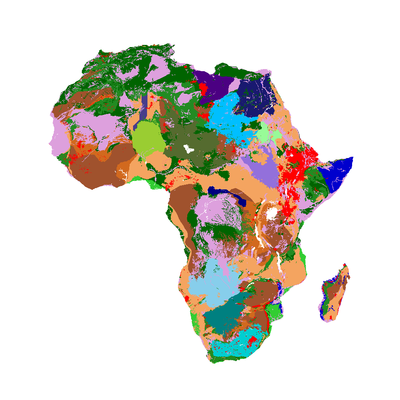
Geology of Africa, 1:5 million scale. From USGS (Persits et al. 2002). -
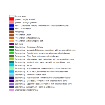
Legend for geology map of Africa, 1:5 million scale. From USGS (Persits et al. 2002)


The original 1:5 million scale map of geology, oil and gas fields and geologic provinces of Africa (Persits et al., 2002), which was used to derive the country-scale geology and hydrogeology maps in this Atlas, is made available through the USGS and can be accessed via the USGS Energy Data Finder.
Citations
Persits, F, Ahlbrandt, T, Tuttle, M, Charpentier, R, Brownfield, M, and Takahashi, K. 2002. | Map showing geology, oil and gas fields and geologic provinces of Africa, Ver 2.0. USGS Open File report 97-470 A.
MacDonald, AM, Bonsor, HC, Ó Dochartaigh, BÉ and Taylor, RG. 2012. | Quantitative maps of groundwater resources in Africa. Environmental Research Letters 7(2). doi: 10.1088/1748-9326/7/2/024009
UNESCO/Association for African Geological Surveys. 1964. Geological Map of Africa. Prepared by UNESCO and the Association for African Geological Surveys. UNESCO, Paris, 1964.
Country geology maps
The new, modified geology map of Africa was used as the basis to produce a geology map for each country in Africa for this Atlas. For some countries, the country map was extracted from the Africa-wide map with no further modifications. For some other countries, further modifications have been made to reflect more accurately the geology at a more detailed, national scale. These modifications were made in collaboration with the co-authors of the relevant country pages, who are experts in the hydrogeology and geology of the respective countries.
Further information about the geology of Africa
OneGeology: another source of geological information
Many countries across Africa (27 in total) are members of OneGeology, an international initiative to make worldwide geological data and maps available at a scale of at least 1:1 million. Further information can be found via the OneGeology website and data can be accessed via the OneGeology portal.
Africa Groundwater Atlas >> Additional resources >> Geology