Case studies: Difference between revisions
Jump to navigation
Jump to search
No edit summary |
|||
| Line 27: | Line 27: | ||
|- | |- | ||
| | | | ||
| [[File:UgandaHiddenCrisis3.jpg|thumb| 400 px| left| Carrying out a pumping test on a failed borehole in Amuria District. | | [[File:UgandaHiddenCrisis3.jpg|thumb| 400 px| left| Carrying out a pumping test on a failed borehole in Amuria District. Image credit: [http://nora.nerc.ac.uk/511071/ Bonsor et al. 2013]]] | ||
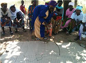
[[File:CommunityDataInterpretationBF.png|thumb| 600px|right| Community members interpreting groundwater level and rainfall data. Image credit: Richard Carter / [https://washmatters.wateraid.org/publications/strengthening-wash-services-and-community-resilience-through-community-based-water WaterAid (2013)]]] | [[File:CommunityDataInterpretationBF.png|thumb| 600px|right| Community members interpreting groundwater level and rainfall data. Image credit: Richard Carter / [https://washmatters.wateraid.org/publications/strengthening-wash-services-and-community-resilience-through-community-based-water WaterAid (2013)]]] | ||
Revision as of 10:08, 28 March 2018
Africa Groundwater Atlas >> Additional resources >> Case studies
This page is still being developed. Please check back soon for even more content.
Case studies
  |
Return to Africa Groundwater Atlas >> Additional resources