Hydrogeology of Morocco: Difference between revisions
Created page with " Africa Groundwater Atlas >> Hydrogeology by country >> Hydrogeology of Morocco ==Authors== '''Kirsty..." |
No edit summary |
||
| Line 1: | Line 1: | ||
[[Overview of Africa Groundwater Atlas | Africa Groundwater Atlas]] >> [[Hydrogeology by country | Hydrogeology by country]] >> Hydrogeology of Morocco | [[Overview of Africa Groundwater Atlas | Africa Groundwater Atlas]] >> [[Hydrogeology by country | Hydrogeology by country]] >> Hydrogeology of Morocco | ||
This page shows a simplified geological and hydrogeological map of Morocco. More information on the geology and hydrogeology of Morocco is available on request, and through the published literature listed in the Reference section, below. | |||
==Authors== | ==Authors== | ||
| Line 5: | Line 9: | ||
==Geographical Setting== | ==Geographical Setting== | ||
Much of Morocco is mountainous, in particular the Atlas mountains in the centre-south and the Rif mountains in the north. | |||
[[File:Morocco_Political.png | right | frame | Map of Morocco (For more information on the datasets used in the map see the [[Geography | geography resources section]])]] | [[File:Morocco_Political.png | right | frame | Map of Morocco (For more information on the datasets used in the map see the [[Geography | geography resources section]])]] | ||
===General=== | ===General=== | ||
{| class = "wikitable" | {| class = "wikitable" | ||
|- | |- | ||
|Estimated Population in 2013* || | |Estimated Population in 2013* || 33,008,150 | ||
|- | |- | ||
|Rural Population (% of total) (2013)* || | |Rural Population (% of total) (2013)* || 40.8% | ||
|- | |- | ||
|Total Surface Area* || | |Total Surface Area* || 446,300 sq km | ||
|- | |- | ||
|Agricultural Land (% of total area) (2012)* || | |Agricultural Land (% of total area) (2012)* || 68.1% | ||
|- | |- | ||
|Capital City || | |Capital City || Rabat | ||
|- | |- | ||
|Region || | |Region || Northern Africa | ||
|- | |- | ||
|Border Countries || | |Border Countries || Moroccan Sahara (Western Sahara), Algeria | ||
|- | |- | ||
|Annual Freshwater Withdrawal (2013)* || | |Annual Freshwater Withdrawal (2013)* || 12,610 Million cubic metres | ||
|- | |- | ||
|Annual Freshwater Withdrawal for Agriculture (2013)* || | |Annual Freshwater Withdrawal for Agriculture (2013)* || 87.3% | ||
|- | |- | ||
|Annual Freshwater Withdrawal for Domestic Use (2013)* || | |Annual Freshwater Withdrawal for Domestic Use (2013)* || 9.8% | ||
|- | |- | ||
|Annual Freshwater Withdrawal for Industry (2013)* || | |Annual Freshwater Withdrawal for Industry (2013)* || 2.9% | ||
|- | |- | ||
|Rural Population with Access to Improved Water Source (2012)* || | |Rural Population with Access to Improved Water Source (2012)* || 63.6% | ||
|- | |- | ||
|Urban Population with Access to Improved Water Source (2012)* || | |Urban Population with Access to Improved Water Source (2012)* || 98.5% | ||
|} | |} | ||
<nowiki>*</nowiki> Source: World Bank | <nowiki>*</nowiki> Source: World Bank | ||
===Climate=== | |||
The north of Morocco has a Mediterranean climate. The Atlas mountains show a range of climatic conditions through humid temperate on their lower slopes to Alpine at their highest elevation. East of the Atlas and in the south, the climate is dry to desert. | |||
<gallery widths="375px" heights=365px mode=nolines> | <gallery widths="375px" heights=365px mode=nolines> | ||
File: Morocco_ClimateZones.png |Koppen Geiger Climate Zones | File:Morocco_ClimateZones.png |Koppen Geiger Climate Zones | ||
File: Morocco_ClimatePrecip.png |Average Annual Precipitation | File:Morocco_ClimatePrecip.png |Average Annual Precipitation | ||
File: Morocco_ClimateTemp.png |Average Temperature | File:Morocco_ClimateTemp.png |Average Temperature | ||
</gallery> | </gallery> | ||
Rainfall time-series and graphs of monthly average rainfall and temperature for each individual climate zone can be found on the [[Climate of Morocco | Morocco Climate Page]]. | |||
The following graphs show a rainfall time-series over a series of years, and monthly average rainfall and temperature. Rainfall time-series and graphs of monthly average rainfall and temperature for each individual climate zone can be found on the [[Climate of Morocco | Morocco Climate Page]]. | |||
| Line 63: | Line 70: | ||
|- | |- | ||
| | | | ||
| [[File:Morocco_Hydrology.png | frame | Surface Water Map of Morocco]] | |||
| [[File:Western Sahara_Hydrology.png| frame | Surface Water Map of Moroccan Sahara (Western Sahara)]] | |||
|} | |||
Basin (Watershed) Agencies (see Groundwater Management section, below) are responsible for river flow gauging. There are about 700 gauging points in rivers. Gauging is generally done 3 times per month, and again during flood periods. | |||
(For more information on the datasets used in the maps see the [[Surface water | surface water resources section]]) | |||
===Soil=== | ===Soil=== | ||
{| | {| | ||
|- | |- | ||
| [[File: Morocco_soil.png | frame | Soil Map of Morocco | | [[File:Morocco_soil.png | frame |left| Soil Map of Morocco ]] | ||
[[File:Western Sahara_soil.png| frame | right|Soil Map of Moroccan Sahara (Western Sahara) ]] | |||
| | | | ||
|} | |} | ||
(For map key and more information on the datasets used in the map see the [[Soil | soil resources section]]) | |||
===Land cover=== | ===Land cover=== | ||
| Line 90: | Line 104: | ||
This section provides a summary of the geology of Morocco. More detail can be found in the references listed at the bottom of this page. Many of these references can be accessed through the [http://www.bgs.ac.uk/africagroundwateratlas/index.cfm Africa Groundwater Literature Archive]. | This section provides a summary of the geology of Morocco. More detail can be found in the references listed at the bottom of this page. Many of these references can be accessed through the [http://www.bgs.ac.uk/africagroundwateratlas/index.cfm Africa Groundwater Literature Archive]. | ||
The geology | The geology maps on this page show a simplified version of the geology (see [[Geology | the Geology resources page]] for more details). | ||
[[File: Morocco_Geology.png | right]] | [[File: Morocco_Geology.png | right]] | ||
| Line 139: | Line 154: | ||
This section provides a summary of the hydrogeology of the main aquifers in Morocco. More information is available in the references listed at the bottom of this page. Many of these references can be accessed through the [http://www.bgs.ac.uk/africagroundwateratlas/index.cfm Africa Groundwater Literature Archive]. | This section provides a summary of the hydrogeology of the main aquifers in Morocco. More information is available in the references listed at the bottom of this page. Many of these references can be accessed through the [http://www.bgs.ac.uk/africagroundwateratlas/index.cfm Africa Groundwater Literature Archive]. | ||
The hydrogeology map on this page shows a simplified version of the type and productivity of the main aquifers at a national scale (see [[Aquifer properties| the Aquifer properties resource page]] for more details). | The hydrogeology map on this page shows a simplified version of the type and productivity of the main aquifers at a national scale (see [[Aquifer properties| the Aquifer properties resource page]] for more details). | ||
[[File: Morocco_Hydrogeology.png]] [[File: Hydrogeology_Key.png | 500x195px]] | [[File: Morocco_Hydrogeology.png]] [[File: Hydrogeology_Key.png | 500x195px]] | ||
| Line 223: | Line 239: | ||
The following references provide more information on the geology and hydrogeology of Morocco. | The following references provide more information on the geology and hydrogeology of Morocco. | ||
These, and others, can be accessed through the [http://www.bgs.ac.uk/africagroundwateratlas/searchResults.cfm?title_search=&author_search=&category_search=&country_search=MA&placeboolean=AND&singlecountry=1 Africa Groundwater Literature Archive] | These, and others, can be accessed through the [http://www.bgs.ac.uk/africagroundwateratlas/searchResults.cfm?title_search=&author_search=&category_search=&country_search=MA&placeboolean=AND&singlecountry=1 Africa Groundwater Literature Archive]. | ||
===Geology: key references=== | ===Geology: key references=== | ||
'''Geological maps:''' | |||
Hollard H, Choubert G, Bronner G, Marchand J et Sougy J. 1985. Carte géologique du Maroc, scale 1:1,000,000 (2 sheets), 260. See Catalogue des Publications, Service Carte géol. Maroc, Ministère de l’Energie et des Mines, Direction de la Géologie, Service Documentation et Publications. web : www.mem.gov.ma | |||
IGME. 1971. Mapa geolgica del Sahara occidental, scala 1:200.000, Madrid. | |||
Rjimati E et Zemmouri A. 2002. Carte géologique du Maroc au 1/50 000, feuille d’Awsard. Notice explicative. Notes Mém. Serv. Géol. Maroc, 439 bis, 1-38. | |||
Rjimati E, Zemmouri A et al. 2002. Carte géologique du Maroc au 1/100.000, feuille Imliliy (éd. prov.) | |||
Rjimati E, Zemmouri A et al. 2002. Carte géologique du Maroc au 1/100.000, feuille Smara (éd. prov.). | |||
'''Main publications:''' | |||
Arribas A. 1968. El Precámbrico del Sahara español y sus relaciones con la series sedimentarios más modernas. Bol. Geol. Miner. 79, 445-480. | |||
Burkhard M, Caritg S, Helg U, Robert-Charrue C et Soulaimani A. 2006. Tectonics of the Anti-Atlas of Morocco. Comptes Rendus Géosci. 338, 11–24. | |||
Caby R et Kienast JR. 2009. Neoproterozoic and Hercynian metamorphic events in the Central Mauritanides: Implications for the geodynamic evolution of West Africa. J. Afr. Earth. Sci. 53, 122-136. | |||
Choubert G. 1963. Histoire géologique du Précambrien de l’Anti Atlas Marocain. Tome I. Notes et Mémoires du Service Géologique du Maroc, vol. 162, 352 p. | |||
Davison I. 2005. Central Atlantic margin basins of North West Africa: Geology and hydrocarbon potential (Morocco to Guinea). Journal of African Earth Sciences. | |||
Destombes J. 1971. L’Ordovicien au Maroc. Essai de synthèse stratigraphique. Mém. BRGM 73, 237-263. | |||
Destombes J, Hollard H and Willefert S. 1985. Lower Palaeozoic rocks of Morocco. In: Holland, C.H. (Ed.), Lower Palaeozoic rocks of North-Western and West-Central Africa. John Wiley, Chichester, pp. 91–336. | |||
Deynoux M, Sougy J and Trompette R. 1985. Lower Palaeozoic rocks of West Africa and western part of Central Africa. In: Holland H. (Ed.), Lower Palaeozoic rocks of north-western and west central Africa, Wiley & Sons, 337-495. | |||
El Albani A, Kuhnt W, Luderer F, Herbin JP and Caron M. 1999. Palaeoenvironmental evolution of the Late Cretaceous sequence in the Tarfaya Basin (southwest of Morocco). In: Cameron N.R., Bate R.H., Clure V.S. (Eds.), The oil and gas habitats of the South Atlantic. Geol. Soc. London Spec. Pub. 153, 223-240. | |||
Fabre J. 2005. Géologie du Sahara occidental et central. Tervuren Afr. Geosci. Coll. 108, 572 pp. | |||
Frizon de Lamotte, D, Leturmy P, Missenard Y, Khomsi S, Ruiz G, Saddiqi O, Guillocheau F and Michard A. 2009. Mesozoic and Cenozoic vertical movements in the Atlas system (Algeria, Morocco, Tunisia); an overview. Tectonophysics, 475, 9–28. | |||
Gasquet D, Ennih N, Liégeois JP, Soulaimani A and Michard A. 2008. The Pan-African Belt. In: Michard, A., Saddiqi, O., Chalouan, A., Frizon de Lamotte, D. (Eds.), Continental Evolution: The Geology of Morocco. Springer Verl, pp. 33–64. | |||
Hollard H. 1967. Le Dévonien du Maroc et du Sahara nord occidental. Intern. Symp. Devonian System, Calgary, Alberta Soc. Petrol. Geol. 1, 203-244. | |||
Keller G, Adatte T, Berner Z, Chellai EH and Stueben D. 2008. Oceanic events and biotic effects of the Cenomanian-Turonian anxic event, Tarfaya Basin, Morocco. Cretaceous Res. 29, 976-994. | |||
Le Goff E, Guerrot C, Maurin G, Johan V, Tegyey M et Ben Zarga M. 2001. Découverte d’éclogites hercyniennes dans la chaîne septentrionale des Mauritanides (Afrique de l’Ouest). Comptes Rendus de la Académie des Sciences de Paris, Sciences de la Terre et des planètes 333, 711-718. | |||
Lécorché JP, Bronner G, Dallmeyer RD, Rocci G and Roussel J. 1991. The Mauritanide Orogen and its northern extensions (Western Sahara and Zemmour), West Africa. In: Dallmeyer R.D., Lécorché J.P. (Eds.), The West African Orogen and Circum-Atlantic correlatives, Springer Verl., 187-227. | |||
Michard A, Hoepffner C, Soulaimani A and Baidder L. 2008. Chapt. 3: The Variscan Belt. In : Michard A., Saddiqi O., Chalouan A., Frizon de Lamotte D. (Eds.), Continental Evolution: The Geology of Morocco, LNES 116, Springer Verl., 65-131. | |||
Michard A, Soulaimani A, Hoepffner C, Ouanaimi H, Baidder L, Rjimati EC and Saddiqi O. 2010. The South-Western Branch of the Variscan Belt: evidence from Morocco. Tectonophysics 492, 1-24, doi:10.1016/j.tect.2010.05.021. | |||
Montero P, Haissen F, El Archi A, Rjimati E, Bea, F. 2014. Timing of Archean crust formation and cratonization in the Awsard-Tichla zone of the NW Reguibat Rise, West African Craton: A SHRIMP, Nd-Sr isotopes, and geochemical reconnaissance study. Precambrian Research 242, 112-137. | |||
Mort HP, Adatte T, Keller G, Bartels D, Föllmi KB, Steinmann P, Berner Z and Chellai EH. 2008. Organic carbon deposition and phosphorus accumulation during Oceanic Anoxic Event 2 in Tarfaya, Morocco. Cretaceous Res. 29, 1008-1023. | |||
O’Connor EA, Barnes RP, Beddoe-Stephens B, Fletcher T, Gillespie MR, Hawkins MP, Loughlin SC, Smith M, Smith RA, Waters CN and Williams M. 2010. Geology of the Drâa, Kerdous and Boumalne districts, Anti-Atlas, Morocco. British Geological Survey, 324 pp. | |||
Planchon JP. 1967. Observations sur le Dévonien inférieur du Sahara espagnol (Région de Smara). Mém. BRGM 33, 321-325. | |||
Quirol. 1976. Regional Geology of the Moroccan Sahara,” Bureau de Recherche et de Participations Minières, 1976. | |||
Ranke U, Von Raad U and Wissmann G. 1982. Stratigraphy, Facies, and Tectonic Development of On- and Offshore Aaiun-Tarfaya Basin a Review. In: U. Von Raad, Ed., Geology of the North West African Continental Margin, Springer-Verlag, Berlin, 1982, pp. 86-104. doi:10.1007/978-3-642-68409-8_6 | |||
Sachse VF, Littke R, Heim S, Kluth O, Schober J, Boutib L, Jabour H, Perssen F and Sindern S. 2010. Petroleum source rocks of the Tarfaya Basin and adjacent areas. Organic Geochem., doi: 10106/j.orggeochem.2010.12.004 | |||
Sougy J. 1964. Les formations paléozoïques du Zemmour Noir (Mauritanie septentrionale). Etude stratigraphique, pétrographique et paléontologique. Ann. Fac. Sci. Dakar, sér. Sci. Terre 15, I-12, 695 pp. | |||
Sougy J. 1969. Grandes lignes structurales de la chaîne des Mauritanides et de son avant-pays (socle précambrien et sa couverture infracambrienne et paléozoïque), Afrique de l’Ouest. Bull. Soc. géol. Fr. (7) 11, 133-149. | |||
Thomas RJ, Fekkak A, Ennih N, Errami E, Loughlin SC, Gresse PG, Chevallier LP and Liegeois JP. 2004. A new lithostratigraphic framework for the Anti-Atlas Orogen, Morocco. J. Afr. Earth Sci. 39, 217–226. | |||
Thomas RJ, Chevallier LP, Gresse PG, Harmer RE, Eglington BM, Armstrong RA. de Beer CH, Martini JEJ, de Kock GS, Macey PH and Ingram BA. 2002. Precambrian evolution of the Sirwa Window, Anti-Atlas Orogen, Morocco. Precambr. Res. 118, 1–57. | |||
Uchupi E K, Emery KO, Bowin CO et al. 1976. Conti- nental Margin off Western Africa from Senegal to Portu- gal,” Bulletin American Association of Petroleum Geolo-gists, Vol. 60, pp. 809-878. | |||
Villeneuve M, Bellon H, El Archi A, Sahabi M, Rehault J-P, Olivet J-L et Aghzer AM. 2006. Evénements panafricains dans l’Adrar Souttouf (Sahara marocain). C. R. Geosci. 338, 359-367. | |||
Villeneuve M. 2008. Review of the orogenic belts on the western side of the West African craton: the Bassarides, Rokelides and Mauritanides. In: Ennih, N., Liégeois, J.-P., 2008. The Boundaries of the West African Craton. Geological Society of London, Special Publications 297, 169-201. | |||
Villeneuve M, El Archi A et Nzamba J. 2010. Les chaînes de la marge occidentale du craton ouest africain, modèles géodynamiques. Comptes Rendus Geoscience 342, 1-10. | |||
Villeneuve M and Marcaillou B. 2013. Pre-Mesozoic origin and paleogeography of blocks in the Caribbean, South Appalachian and West African domains and their impact on the post “variscan” evolution. Bulletin de la Société Géologique de France 184, 1-20. | |||
Von Rad U and Wissmann G. 1982. Cretaceous-Cenozoic History of the West Saharan Continental Margin (NW Africa): Development, Destruction and Gravitational Se- dimentation in Geology of NW Africa. In: U. Von Raad, Ed., Geology of the North West African Continental Mar- gin, Springer-Verlag, Berlin, 1982, pp. 106-129. | |||
===Hydrogeology: key references=== | ===Hydrogeology: key references=== | ||
'''Key sources of online information:''' | |||
http://www.water.gov.ma | |||
http://www.mem.gov.ma | |||
'''Reports and publications:''' | |||
Agoussine M et Bouchaou L. 2004. Les problèmes majeurs de la gestion de l’eau au Maroc. Science et changements planétaires / Sécheresse. Numéro 15, volume 2, 187-94. | |||
Alaoui M. 2013. Water sector in Morocco: situation and perspectives. Journal of Water Resources and Ocean Science; 2(5): 108-114 | |||
Benaabidate L and Fryar AE. 2010. Controls on Ground Water Chemistry in the Central Couloir Sud Rifain, Morocco. Vol. 48, No. 2–GROUND WATER–March-April 2010 (pages 306–319). | |||
Ben Kabbour B, Zouhri L, Mania J and Colbeaux J P. 2007. Assessing groundwater contamination risk using the DASTI/IDRISI GIS method: coastal system of western Mamora, Morocco. Bulletin of Engineering Geology and the Environment. November 2007, Volume 66, Issue 4, p 507. | |||
Bouchaou L, Tagma T, Hsissou Y, Ikenne M, Boutaleb S, Bouragba L, Mudry J and Michelot JL. 2009. Isotopic study of the relationship between surface water and groundwater under a semi-arid climate: case of souss-massa basin (south-western morocco). IAHS Red Book series, Vol. 334, 15. | |||
Bouchaou L, Michelot JL, Qurtobi M, Zine N, Gaye CB, Aggarwal PK, Marah H, Zerouali A, Taleb H and Vengosh A. 2009. Origin and residence time of groundwater in the Tadla basin (Morocco) using multiple isotopic and geochemical tools. Journal of Hydrology, Volume 379, Issues 3–4, 30 December 2009, Pages 323-338 | |||
Bouchaou L, Tagma T,Boutaleb S, Hssaisoune M and El Morjani Z. 2011. Climate change and its impacts on groundwater resources in Morocco: the case of the Souss- Massa basin. International Contributions to Hydrogeology: Climate Change Effects on Groundwater Resources: A Global Synthesis of Findings and Recommendations. Editor(s): Holger Treidel & Jose Luis Martin-Bordes. CRC press Taylor & Francis group. IAH Book series, Vol. 27, ISBN: 978-0-415-68936-6. Chap. 8, 129-144 Pages: 414. | |||
Bouchaou L, Michelot JL, Vengosh A, Hsissou Y, Qurtobi M, Gaye CB, Bullen TD and Zuppi GM. 2008. Application of multiple isotopic and geochemical tracers for investigation of recharge, salinization, and residence time of water in the Souss-Massa aquifer, Southwest of Morocco. J. Hydrol. Vol. 352, 267-287. | |||
Boutaleb S, Boualoul M, Bouchaou L and Oudra M. 2008. Application of remote-sensing and surface geophysics for groundwater prospecting in a hard rock terrain, Morocco. Applied Groundwater study in Africa, Taylor and Francis Group Series editors:.IAH Book series, Vol. 13, Chap. 13, 215-231. | |||
Chofqi A, Younsi, Lhadi E, Mania J, Mudry J and Veron A. 2004. Environmental impact of an urban landfill on a coastal aquifer (El Jadida, Morocco). Journal of African Earth Sciences, Volume 39, Issues 3–5, June–August 2004,Pages 509-516 | |||
CSEC (Conseil superior de l’Eau et du Climat). 2013. Le Plan National de l’Eau : rapport final. Le Conseil Supérieur de l’Eau et du Climat, Mai 2013, 148 p. | |||
De Jong C, Cappy S, Finckh M and Funk D. 2008. A transdisciplinary analysis of water problems in the mountainous karst areas of Morocco. Engineering Geology, Volume 99, Issues 3–4, 23 June 2008, Pages 228-238 | |||
Driouech F, Déqué M and Sánchez-Gómez E. 2010. Weather regimes—Moroccan precipitation link in a regional climate change simulation. Global and Planetary Change 72, 1–10. | |||
El Khalil H, El Hamiani O, Bitton N and Boularbah A. 2008. Heavy metal contamination from mining sites in South Morocco: Monitoring metal content and toxicity of soil runoff and groundwater. Environmental Monitoring and Assessment. Volume 136, Issue 1-3, pp 147-160 | |||
Essahlaoui A, Sahbi H, Bahi L and El-Yamine N. 2001. Reconnaissance de la structure géologique du bassin de saïss occidental, Maroc, par sondages électriques. Journal of African Earth Sciences, Volume 32, Issue 4, May 2001, Pages 777-789 | |||
Ettazarini S. 2006. Mapping of groundwater quality in the Turonian aquifer of Oum Er-Rabia Basin, Morocco: a case study. Environmental Geology. Volume 50, Issue 6, pp 919-929. | |||
Ettayfi N, Bouchaou L, Michelot JL, Tagma T, Warner N, Boutaleb S, Massault M, Lgourna Z and Vengosh A. 2012. Geochemical and isotopic (oxygen, hydrogen, carbon, strontium) constraints for the origin, salinity, and residence time of groundwater from a carbonate aquifer in the Western Anti-Atlas Mountains,Morocco. Journal of Hydrology, Volumes 438–439, 17 May 2012, Pages 97-111 | |||
Food and Agriculture Organization of the United Nations (FAO). 2009. Groundwater Management in Morocco - Draft Synthesis Report (FAO), Rome. http://www.groundwatergovernance.org | |||
Houdret A. The Water Connection: Irrigation, Water Grabbing and Politics in Southern Morocco. Water Alternatives 5(2): 284-303. www.water alternatives.org | |||
Jarar Oulidi H, Benaabidate L, Löwner R and Fryar AE. 2008. Management Strategies of Water Resources in the Arid Zone of South-Eastern Morocco. Climatic Changes and Water Resources in the Middle East and North Africa. Environmental Science and Engineering 2008, pp 227-238 | |||
Jarar Oulidi H, Löwner R, Benaabidate L and Joachim W. 2009. HydrIS: An open source GIS decision support system for groundwater management (Morocco). Geo-spatial Information Science. September 2009, Volume 12, Issue 3, pp 212-216. | |||
Khattach D, Keating P, Mili E, Chennouf T, Andrieux P and Milhi A. 2004. Apport de la gravimétrie à l'étude de la structure du bassin des Triffa (Maroc nord-oriental) : implications hydrogéologiques. Comptes Rendus Geoscience, Volume 336, Issue 16, December 2004, Pages 1427-1432 | |||
Laftouhi N, Vanclooster M, Jalal M, Witam O, Aboufirassi M, Bahir M and Persoons É. 2003. Groundwater nitrate pollution in the Essaouira Basin (Morocco). Comptes Rendus Geoscience, Volume 335, Issue 3, March 2003, Pages 307-317. | |||
Le Page M, Berjamy B, Fafir Y, Bourgin F, Jarlan L, Abourida A, Benrhanem M, Jacob G, Huber M, Sghrer F, Simonneux V and Chehbouni G. 2012 . An Integrated DSS for Groundwater Management Based on Remote Sensing. The Case of a Semi-arid Aquifer in Morocco. Water Resources Management. Volume 26, Issue 11, pp 3209-3230 | |||
Ministere de l'Energie, des Mines, de l'Eau et de l'Environnement. Grands Axes De La Strategie Nationale De L’eau. http://www.environnement.gov.ma/PDFs/EAU/axes_strategie.pdf | |||
Ministere de l'Energie, des Mines, de l'Eau et de l'Environnement. 2012. Politique de l'Eau au Maroc. http://unstats.un.org/unsd/envaccounting/workshops/Morocco2012/mrc2012-12.PDF | |||
Re V, Sacchi E and Allais E. 2013. The Use of Nitrate Isotopes to Identify Contamination Sources in the Bou-Areg Aquifer (Morocco). Procedia Earth and Planetary Science, Volume 7, 2013, Pages 729-732 | |||
Re V, Sacchi E, Martin-Bordes JL, Aureli A, El Hamouti N, Bouchnan R and Zuppi GM. 2013. Processes affecting groundwater quality in arid zones: The case of the Bou-Areg coastal aquifer (North Morocco). Applied Geochemistry, Volume 34, July 2013, Pages 181-198 | |||
Re V, Sacchi E, Mas-Pla J, Menció A and El Amrani N. 2014. Identifying the effects of human pressure on groundwater quality to support water management strategies in coastal regions: A multi-tracer and statistical approach (Bou-Areg region, Morocco). Science of The Total Environment, Volumes 500–501, 1 December 2014, Pages 211-223 | |||
Sardinha J, Carneiro JF, Zarhloule Y, Barkaoui A, Correia A, Boughriba M, Rimi A and El Houadi B. 2012. Structural and hydrogeological features of a Lias carbonate aquifer in the Triffa Plain, NE Morocco. Journal of African Earth Sciences. Vol. 73–74, Pages 24–32 | |||
Schilling J, Freier KP, Hertig E and Scheffran J. 2012. Climate change, vulnerability and adaptation in North Africa with focus on Morocco. Agriculture, Ecosystems and Environment 156, 12– 26 | |||
Taleb H. 2006. Water management in Morocco. Management of Intentional and Accidental Water Pollution. NATO Security through Science Series 2006, pp 177-180. | |||
UN. 1988. Morocco: in Ground water in North and West Africa. Natural Resources/Water Series No. 18, ST/TCD/5. United Nations Department of Technical Cooperation for Development and Economic Commission for Africa. | |||
Warner N, Lgourna Z, Bouchaou L, Boutaleb S, Tagma T, Hsaissoune M and Vengosh A. 2013. Integration of geochemical and isotopic tracers for elucidating water sources and salinization of shallow aquifers in the sub-Saharan Drâa Basin, Morocco. Applied Geochemistry, Volume 34, July 2013, Pages 140-151 | |||
Ziyad A. Gestion des ressources en eau au Maroc : bilan et perspectives. Revue HTE N°142 • Mars - Juin 2009. http://www.anafide.org/doc/HTE%20142/142-6.pdf | |||
Zouhri L. 2001. L'aquifère du bassin de la Mamora, Maroc: geometrie et ecoulements souterrains. Journal of African Earth Sciences, Volume 32, Issue 4, May 2001, Pages 837-850 | |||
==Return to the index pages== | ==Return to the index pages== | ||
Revision as of 17:01, 2 September 2015
Africa Groundwater Atlas >> Hydrogeology by country >> Hydrogeology of Morocco
This page shows a simplified geological and hydrogeological map of Morocco. More information on the geology and hydrogeology of Morocco is available on request, and through the published literature listed in the Reference section, below.
Authors
Kirsty Upton and Brighid Ó Dochartaigh, British Geological Survey, UK
Geographical Setting
Much of Morocco is mountainous, in particular the Atlas mountains in the centre-south and the Rif mountains in the north.

General
| Estimated Population in 2013* | 33,008,150 |
| Rural Population (% of total) (2013)* | 40.8% |
| Total Surface Area* | 446,300 sq km |
| Agricultural Land (% of total area) (2012)* | 68.1% |
| Capital City | Rabat |
| Region | Northern Africa |
| Border Countries | Moroccan Sahara (Western Sahara), Algeria |
| Annual Freshwater Withdrawal (2013)* | 12,610 Million cubic metres |
| Annual Freshwater Withdrawal for Agriculture (2013)* | 87.3% |
| Annual Freshwater Withdrawal for Domestic Use (2013)* | 9.8% |
| Annual Freshwater Withdrawal for Industry (2013)* | 2.9% |
| Rural Population with Access to Improved Water Source (2012)* | 63.6% |
| Urban Population with Access to Improved Water Source (2012)* | 98.5% |
* Source: World Bank
Climate
The north of Morocco has a Mediterranean climate. The Atlas mountains show a range of climatic conditions through humid temperate on their lower slopes to Alpine at their highest elevation. East of the Atlas and in the south, the climate is dry to desert.
-
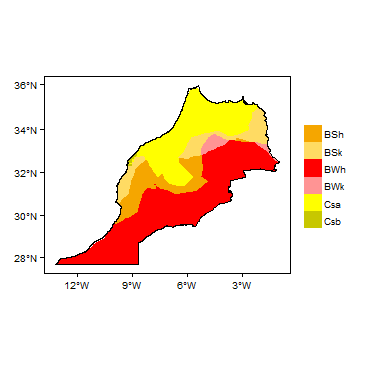 Koppen Geiger Climate Zones
 -
 Average Annual Precipitation
 -
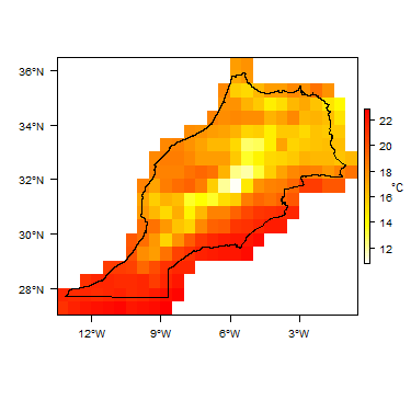 Average Temperature


The following graphs show a rainfall time-series over a series of years, and monthly average rainfall and temperature. Rainfall time-series and graphs of monthly average rainfall and temperature for each individual climate zone can be found on the Morocco Climate Page.


For further detail on the climate datasets used see the climate resources section.
Surface water
 |
 |
Basin (Watershed) Agencies (see Groundwater Management section, below) are responsible for river flow gauging. There are about 700 gauging points in rivers. Gauging is generally done 3 times per month, and again during flood periods.
(For more information on the datasets used in the maps see the surface water resources section)
Soil
  |
(For map key and more information on the datasets used in the map see the soil resources section)
Land cover
 |
Geology
This section provides a summary of the geology of Morocco. More detail can be found in the references listed at the bottom of this page. Many of these references can be accessed through the Africa Groundwater Literature Archive.
The geology maps on this page show a simplified version of the geology (see the Geology resources page for more details).
| Key Formations | Period | Lithology | Structure |
| Geological Environment 1 | |||
|---|---|---|---|
| Name of formation1 | Time period | Description | Structure |
| Geological Environment 2 | |||
| Geological Environment 3 | |||
Hydrogeology
This section provides a summary of the hydrogeology of the main aquifers in Morocco. More information is available in the references listed at the bottom of this page. Many of these references can be accessed through the Africa Groundwater Literature Archive.
The hydrogeology map on this page shows a simplified version of the type and productivity of the main aquifers at a national scale (see the Aquifer properties resource page for more details).
File:Morocco Hydrogeology.png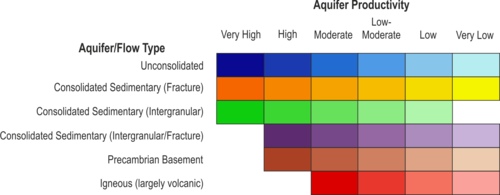

Unconsolidated
| Named Aquifers | General Description | Water quantity issues | Water quality issues | Recharge |
Sedimentary - Intergranular Flow
| Named Aquifers | General Description | Water quantity issues | Water quality issues | Recharge |
Sedimentary - Intergranular & Fracture Flow
| Named Aquifers | General Description | Water quantity issues | Water quality issues | Recharge |
Sedimentary - Fracture Flow
| Named Aquifers | General Description | Water quantity issues | Water quality issues | Recharge |
Basement
| Named Aquifers | General Description | Water quantity issues | Water quality issues | Recharge |
Groundwater Status
Groundwater quantity
Groundwater quality
Groundwater use and management
Groundwater use
Groundwater management
Groundwater monitoring
Transboundary aquifers
For further information about transboundary aquifers, please see the Transboundary aquifers resources page
References
The following references provide more information on the geology and hydrogeology of Morocco. These, and others, can be accessed through the Africa Groundwater Literature Archive.
Geology: key references
Geological maps:
Hollard H, Choubert G, Bronner G, Marchand J et Sougy J. 1985. Carte géologique du Maroc, scale 1:1,000,000 (2 sheets), 260. See Catalogue des Publications, Service Carte géol. Maroc, Ministère de l’Energie et des Mines, Direction de la Géologie, Service Documentation et Publications. web : www.mem.gov.ma
IGME. 1971. Mapa geolgica del Sahara occidental, scala 1:200.000, Madrid.
Rjimati E et Zemmouri A. 2002. Carte géologique du Maroc au 1/50 000, feuille d’Awsard. Notice explicative. Notes Mém. Serv. Géol. Maroc, 439 bis, 1-38.
Rjimati E, Zemmouri A et al. 2002. Carte géologique du Maroc au 1/100.000, feuille Imliliy (éd. prov.)
Rjimati E, Zemmouri A et al. 2002. Carte géologique du Maroc au 1/100.000, feuille Smara (éd. prov.).
Main publications:
Arribas A. 1968. El Precámbrico del Sahara español y sus relaciones con la series sedimentarios más modernas. Bol. Geol. Miner. 79, 445-480.
Burkhard M, Caritg S, Helg U, Robert-Charrue C et Soulaimani A. 2006. Tectonics of the Anti-Atlas of Morocco. Comptes Rendus Géosci. 338, 11–24.
Caby R et Kienast JR. 2009. Neoproterozoic and Hercynian metamorphic events in the Central Mauritanides: Implications for the geodynamic evolution of West Africa. J. Afr. Earth. Sci. 53, 122-136.
Choubert G. 1963. Histoire géologique du Précambrien de l’Anti Atlas Marocain. Tome I. Notes et Mémoires du Service Géologique du Maroc, vol. 162, 352 p.
Davison I. 2005. Central Atlantic margin basins of North West Africa: Geology and hydrocarbon potential (Morocco to Guinea). Journal of African Earth Sciences.
Destombes J. 1971. L’Ordovicien au Maroc. Essai de synthèse stratigraphique. Mém. BRGM 73, 237-263.
Destombes J, Hollard H and Willefert S. 1985. Lower Palaeozoic rocks of Morocco. In: Holland, C.H. (Ed.), Lower Palaeozoic rocks of North-Western and West-Central Africa. John Wiley, Chichester, pp. 91–336.
Deynoux M, Sougy J and Trompette R. 1985. Lower Palaeozoic rocks of West Africa and western part of Central Africa. In: Holland H. (Ed.), Lower Palaeozoic rocks of north-western and west central Africa, Wiley & Sons, 337-495.
El Albani A, Kuhnt W, Luderer F, Herbin JP and Caron M. 1999. Palaeoenvironmental evolution of the Late Cretaceous sequence in the Tarfaya Basin (southwest of Morocco). In: Cameron N.R., Bate R.H., Clure V.S. (Eds.), The oil and gas habitats of the South Atlantic. Geol. Soc. London Spec. Pub. 153, 223-240.
Fabre J. 2005. Géologie du Sahara occidental et central. Tervuren Afr. Geosci. Coll. 108, 572 pp.
Frizon de Lamotte, D, Leturmy P, Missenard Y, Khomsi S, Ruiz G, Saddiqi O, Guillocheau F and Michard A. 2009. Mesozoic and Cenozoic vertical movements in the Atlas system (Algeria, Morocco, Tunisia); an overview. Tectonophysics, 475, 9–28.
Gasquet D, Ennih N, Liégeois JP, Soulaimani A and Michard A. 2008. The Pan-African Belt. In: Michard, A., Saddiqi, O., Chalouan, A., Frizon de Lamotte, D. (Eds.), Continental Evolution: The Geology of Morocco. Springer Verl, pp. 33–64.
Hollard H. 1967. Le Dévonien du Maroc et du Sahara nord occidental. Intern. Symp. Devonian System, Calgary, Alberta Soc. Petrol. Geol. 1, 203-244.
Keller G, Adatte T, Berner Z, Chellai EH and Stueben D. 2008. Oceanic events and biotic effects of the Cenomanian-Turonian anxic event, Tarfaya Basin, Morocco. Cretaceous Res. 29, 976-994.
Le Goff E, Guerrot C, Maurin G, Johan V, Tegyey M et Ben Zarga M. 2001. Découverte d’éclogites hercyniennes dans la chaîne septentrionale des Mauritanides (Afrique de l’Ouest). Comptes Rendus de la Académie des Sciences de Paris, Sciences de la Terre et des planètes 333, 711-718.
Lécorché JP, Bronner G, Dallmeyer RD, Rocci G and Roussel J. 1991. The Mauritanide Orogen and its northern extensions (Western Sahara and Zemmour), West Africa. In: Dallmeyer R.D., Lécorché J.P. (Eds.), The West African Orogen and Circum-Atlantic correlatives, Springer Verl., 187-227.
Michard A, Hoepffner C, Soulaimani A and Baidder L. 2008. Chapt. 3: The Variscan Belt. In : Michard A., Saddiqi O., Chalouan A., Frizon de Lamotte D. (Eds.), Continental Evolution: The Geology of Morocco, LNES 116, Springer Verl., 65-131.
Michard A, Soulaimani A, Hoepffner C, Ouanaimi H, Baidder L, Rjimati EC and Saddiqi O. 2010. The South-Western Branch of the Variscan Belt: evidence from Morocco. Tectonophysics 492, 1-24, doi:10.1016/j.tect.2010.05.021.
Montero P, Haissen F, El Archi A, Rjimati E, Bea, F. 2014. Timing of Archean crust formation and cratonization in the Awsard-Tichla zone of the NW Reguibat Rise, West African Craton: A SHRIMP, Nd-Sr isotopes, and geochemical reconnaissance study. Precambrian Research 242, 112-137.
Mort HP, Adatte T, Keller G, Bartels D, Föllmi KB, Steinmann P, Berner Z and Chellai EH. 2008. Organic carbon deposition and phosphorus accumulation during Oceanic Anoxic Event 2 in Tarfaya, Morocco. Cretaceous Res. 29, 1008-1023.
O’Connor EA, Barnes RP, Beddoe-Stephens B, Fletcher T, Gillespie MR, Hawkins MP, Loughlin SC, Smith M, Smith RA, Waters CN and Williams M. 2010. Geology of the Drâa, Kerdous and Boumalne districts, Anti-Atlas, Morocco. British Geological Survey, 324 pp.
Planchon JP. 1967. Observations sur le Dévonien inférieur du Sahara espagnol (Région de Smara). Mém. BRGM 33, 321-325.
Quirol. 1976. Regional Geology of the Moroccan Sahara,” Bureau de Recherche et de Participations Minières, 1976.
Ranke U, Von Raad U and Wissmann G. 1982. Stratigraphy, Facies, and Tectonic Development of On- and Offshore Aaiun-Tarfaya Basin a Review. In: U. Von Raad, Ed., Geology of the North West African Continental Margin, Springer-Verlag, Berlin, 1982, pp. 86-104. doi:10.1007/978-3-642-68409-8_6
Sachse VF, Littke R, Heim S, Kluth O, Schober J, Boutib L, Jabour H, Perssen F and Sindern S. 2010. Petroleum source rocks of the Tarfaya Basin and adjacent areas. Organic Geochem., doi: 10106/j.orggeochem.2010.12.004
Sougy J. 1964. Les formations paléozoïques du Zemmour Noir (Mauritanie septentrionale). Etude stratigraphique, pétrographique et paléontologique. Ann. Fac. Sci. Dakar, sér. Sci. Terre 15, I-12, 695 pp.
Sougy J. 1969. Grandes lignes structurales de la chaîne des Mauritanides et de son avant-pays (socle précambrien et sa couverture infracambrienne et paléozoïque), Afrique de l’Ouest. Bull. Soc. géol. Fr. (7) 11, 133-149.
Thomas RJ, Fekkak A, Ennih N, Errami E, Loughlin SC, Gresse PG, Chevallier LP and Liegeois JP. 2004. A new lithostratigraphic framework for the Anti-Atlas Orogen, Morocco. J. Afr. Earth Sci. 39, 217–226.
Thomas RJ, Chevallier LP, Gresse PG, Harmer RE, Eglington BM, Armstrong RA. de Beer CH, Martini JEJ, de Kock GS, Macey PH and Ingram BA. 2002. Precambrian evolution of the Sirwa Window, Anti-Atlas Orogen, Morocco. Precambr. Res. 118, 1–57.
Uchupi E K, Emery KO, Bowin CO et al. 1976. Conti- nental Margin off Western Africa from Senegal to Portu- gal,” Bulletin American Association of Petroleum Geolo-gists, Vol. 60, pp. 809-878.
Villeneuve M, Bellon H, El Archi A, Sahabi M, Rehault J-P, Olivet J-L et Aghzer AM. 2006. Evénements panafricains dans l’Adrar Souttouf (Sahara marocain). C. R. Geosci. 338, 359-367.
Villeneuve M. 2008. Review of the orogenic belts on the western side of the West African craton: the Bassarides, Rokelides and Mauritanides. In: Ennih, N., Liégeois, J.-P., 2008. The Boundaries of the West African Craton. Geological Society of London, Special Publications 297, 169-201.
Villeneuve M, El Archi A et Nzamba J. 2010. Les chaînes de la marge occidentale du craton ouest africain, modèles géodynamiques. Comptes Rendus Geoscience 342, 1-10.
Villeneuve M and Marcaillou B. 2013. Pre-Mesozoic origin and paleogeography of blocks in the Caribbean, South Appalachian and West African domains and their impact on the post “variscan” evolution. Bulletin de la Société Géologique de France 184, 1-20.
Von Rad U and Wissmann G. 1982. Cretaceous-Cenozoic History of the West Saharan Continental Margin (NW Africa): Development, Destruction and Gravitational Se- dimentation in Geology of NW Africa. In: U. Von Raad, Ed., Geology of the North West African Continental Mar- gin, Springer-Verlag, Berlin, 1982, pp. 106-129.
Hydrogeology: key references
Key sources of online information:
Reports and publications:
Agoussine M et Bouchaou L. 2004. Les problèmes majeurs de la gestion de l’eau au Maroc. Science et changements planétaires / Sécheresse. Numéro 15, volume 2, 187-94.
Alaoui M. 2013. Water sector in Morocco: situation and perspectives. Journal of Water Resources and Ocean Science; 2(5): 108-114
Benaabidate L and Fryar AE. 2010. Controls on Ground Water Chemistry in the Central Couloir Sud Rifain, Morocco. Vol. 48, No. 2–GROUND WATER–March-April 2010 (pages 306–319).
Ben Kabbour B, Zouhri L, Mania J and Colbeaux J P. 2007. Assessing groundwater contamination risk using the DASTI/IDRISI GIS method: coastal system of western Mamora, Morocco. Bulletin of Engineering Geology and the Environment. November 2007, Volume 66, Issue 4, p 507.
Bouchaou L, Tagma T, Hsissou Y, Ikenne M, Boutaleb S, Bouragba L, Mudry J and Michelot JL. 2009. Isotopic study of the relationship between surface water and groundwater under a semi-arid climate: case of souss-massa basin (south-western morocco). IAHS Red Book series, Vol. 334, 15.
Bouchaou L, Michelot JL, Qurtobi M, Zine N, Gaye CB, Aggarwal PK, Marah H, Zerouali A, Taleb H and Vengosh A. 2009. Origin and residence time of groundwater in the Tadla basin (Morocco) using multiple isotopic and geochemical tools. Journal of Hydrology, Volume 379, Issues 3–4, 30 December 2009, Pages 323-338
Bouchaou L, Tagma T,Boutaleb S, Hssaisoune M and El Morjani Z. 2011. Climate change and its impacts on groundwater resources in Morocco: the case of the Souss- Massa basin. International Contributions to Hydrogeology: Climate Change Effects on Groundwater Resources: A Global Synthesis of Findings and Recommendations. Editor(s): Holger Treidel & Jose Luis Martin-Bordes. CRC press Taylor & Francis group. IAH Book series, Vol. 27, ISBN: 978-0-415-68936-6. Chap. 8, 129-144 Pages: 414.
Bouchaou L, Michelot JL, Vengosh A, Hsissou Y, Qurtobi M, Gaye CB, Bullen TD and Zuppi GM. 2008. Application of multiple isotopic and geochemical tracers for investigation of recharge, salinization, and residence time of water in the Souss-Massa aquifer, Southwest of Morocco. J. Hydrol. Vol. 352, 267-287.
Boutaleb S, Boualoul M, Bouchaou L and Oudra M. 2008. Application of remote-sensing and surface geophysics for groundwater prospecting in a hard rock terrain, Morocco. Applied Groundwater study in Africa, Taylor and Francis Group Series editors:.IAH Book series, Vol. 13, Chap. 13, 215-231.
Chofqi A, Younsi, Lhadi E, Mania J, Mudry J and Veron A. 2004. Environmental impact of an urban landfill on a coastal aquifer (El Jadida, Morocco). Journal of African Earth Sciences, Volume 39, Issues 3–5, June–August 2004,Pages 509-516
CSEC (Conseil superior de l’Eau et du Climat). 2013. Le Plan National de l’Eau : rapport final. Le Conseil Supérieur de l’Eau et du Climat, Mai 2013, 148 p.
De Jong C, Cappy S, Finckh M and Funk D. 2008. A transdisciplinary analysis of water problems in the mountainous karst areas of Morocco. Engineering Geology, Volume 99, Issues 3–4, 23 June 2008, Pages 228-238
Driouech F, Déqué M and Sánchez-Gómez E. 2010. Weather regimes—Moroccan precipitation link in a regional climate change simulation. Global and Planetary Change 72, 1–10.
El Khalil H, El Hamiani O, Bitton N and Boularbah A. 2008. Heavy metal contamination from mining sites in South Morocco: Monitoring metal content and toxicity of soil runoff and groundwater. Environmental Monitoring and Assessment. Volume 136, Issue 1-3, pp 147-160
Essahlaoui A, Sahbi H, Bahi L and El-Yamine N. 2001. Reconnaissance de la structure géologique du bassin de saïss occidental, Maroc, par sondages électriques. Journal of African Earth Sciences, Volume 32, Issue 4, May 2001, Pages 777-789
Ettazarini S. 2006. Mapping of groundwater quality in the Turonian aquifer of Oum Er-Rabia Basin, Morocco: a case study. Environmental Geology. Volume 50, Issue 6, pp 919-929.
Ettayfi N, Bouchaou L, Michelot JL, Tagma T, Warner N, Boutaleb S, Massault M, Lgourna Z and Vengosh A. 2012. Geochemical and isotopic (oxygen, hydrogen, carbon, strontium) constraints for the origin, salinity, and residence time of groundwater from a carbonate aquifer in the Western Anti-Atlas Mountains,Morocco. Journal of Hydrology, Volumes 438–439, 17 May 2012, Pages 97-111
Food and Agriculture Organization of the United Nations (FAO). 2009. Groundwater Management in Morocco - Draft Synthesis Report (FAO), Rome. http://www.groundwatergovernance.org
Houdret A. The Water Connection: Irrigation, Water Grabbing and Politics in Southern Morocco. Water Alternatives 5(2): 284-303. www.water alternatives.org
Jarar Oulidi H, Benaabidate L, Löwner R and Fryar AE. 2008. Management Strategies of Water Resources in the Arid Zone of South-Eastern Morocco. Climatic Changes and Water Resources in the Middle East and North Africa. Environmental Science and Engineering 2008, pp 227-238
Jarar Oulidi H, Löwner R, Benaabidate L and Joachim W. 2009. HydrIS: An open source GIS decision support system for groundwater management (Morocco). Geo-spatial Information Science. September 2009, Volume 12, Issue 3, pp 212-216.
Khattach D, Keating P, Mili E, Chennouf T, Andrieux P and Milhi A. 2004. Apport de la gravimétrie à l'étude de la structure du bassin des Triffa (Maroc nord-oriental) : implications hydrogéologiques. Comptes Rendus Geoscience, Volume 336, Issue 16, December 2004, Pages 1427-1432
Laftouhi N, Vanclooster M, Jalal M, Witam O, Aboufirassi M, Bahir M and Persoons É. 2003. Groundwater nitrate pollution in the Essaouira Basin (Morocco). Comptes Rendus Geoscience, Volume 335, Issue 3, March 2003, Pages 307-317.
Le Page M, Berjamy B, Fafir Y, Bourgin F, Jarlan L, Abourida A, Benrhanem M, Jacob G, Huber M, Sghrer F, Simonneux V and Chehbouni G. 2012 . An Integrated DSS for Groundwater Management Based on Remote Sensing. The Case of a Semi-arid Aquifer in Morocco. Water Resources Management. Volume 26, Issue 11, pp 3209-3230
Ministere de l'Energie, des Mines, de l'Eau et de l'Environnement. Grands Axes De La Strategie Nationale De L’eau. http://www.environnement.gov.ma/PDFs/EAU/axes_strategie.pdf
Ministere de l'Energie, des Mines, de l'Eau et de l'Environnement. 2012. Politique de l'Eau au Maroc. http://unstats.un.org/unsd/envaccounting/workshops/Morocco2012/mrc2012-12.PDF
Re V, Sacchi E and Allais E. 2013. The Use of Nitrate Isotopes to Identify Contamination Sources in the Bou-Areg Aquifer (Morocco). Procedia Earth and Planetary Science, Volume 7, 2013, Pages 729-732
Re V, Sacchi E, Martin-Bordes JL, Aureli A, El Hamouti N, Bouchnan R and Zuppi GM. 2013. Processes affecting groundwater quality in arid zones: The case of the Bou-Areg coastal aquifer (North Morocco). Applied Geochemistry, Volume 34, July 2013, Pages 181-198
Re V, Sacchi E, Mas-Pla J, Menció A and El Amrani N. 2014. Identifying the effects of human pressure on groundwater quality to support water management strategies in coastal regions: A multi-tracer and statistical approach (Bou-Areg region, Morocco). Science of The Total Environment, Volumes 500–501, 1 December 2014, Pages 211-223
Sardinha J, Carneiro JF, Zarhloule Y, Barkaoui A, Correia A, Boughriba M, Rimi A and El Houadi B. 2012. Structural and hydrogeological features of a Lias carbonate aquifer in the Triffa Plain, NE Morocco. Journal of African Earth Sciences. Vol. 73–74, Pages 24–32
Schilling J, Freier KP, Hertig E and Scheffran J. 2012. Climate change, vulnerability and adaptation in North Africa with focus on Morocco. Agriculture, Ecosystems and Environment 156, 12– 26
Taleb H. 2006. Water management in Morocco. Management of Intentional and Accidental Water Pollution. NATO Security through Science Series 2006, pp 177-180.
UN. 1988. Morocco: in Ground water in North and West Africa. Natural Resources/Water Series No. 18, ST/TCD/5. United Nations Department of Technical Cooperation for Development and Economic Commission for Africa.
Warner N, Lgourna Z, Bouchaou L, Boutaleb S, Tagma T, Hsaissoune M and Vengosh A. 2013. Integration of geochemical and isotopic tracers for elucidating water sources and salinization of shallow aquifers in the sub-Saharan Drâa Basin, Morocco. Applied Geochemistry, Volume 34, July 2013, Pages 140-151
Ziyad A. Gestion des ressources en eau au Maroc : bilan et perspectives. Revue HTE N°142 • Mars - Juin 2009. http://www.anafide.org/doc/HTE%20142/142-6.pdf
Zouhri L. 2001. L'aquifère du bassin de la Mamora, Maroc: geometrie et ecoulements souterrains. Journal of African Earth Sciences, Volume 32, Issue 4, May 2001, Pages 837-850
Return to the index pages
Africa Groundwater Atlas >> Hydrogeology by country >> Hydrogeology of Morocco