Climate of Angola: Difference between revisions
Jump to navigation
Jump to search
KirstyUpton (talk | contribs) No edit summary |
No edit summary |
||
| (2 intermediate revisions by 2 users not shown) | |||
| Line 1: | Line 1: | ||
[[Africa Groundwater Atlas Home | Africa Groundwater Atlas]] >> [[Hydrogeology by country | Hydrogeology by country]] >> [[Hydrogeology of Angola | Hydrogeology of Angola]] >> Climate of Angola | [[Africa Groundwater Atlas Home | Africa Groundwater Atlas]] >> [[Hydrogeology by country | Hydrogeology by country]] >> [[Hydrogeology of Angola | Hydrogeology of Angola]] >> Climate of Angola | ||
==Climate | [[Africa Groundwater Atlas Home | Africa Groundwater Atlas]] >> [[Hydrogeology by country | Hidrogeologia por país]] >> [[Hidrogeologia de Angola | Hidrogeologia de Angola]] >> Clima de Angola | ||
==Climate Zones / Zonas Climáticas== | |||
These maps and graphs were developed from the CRU TS 3.21 dataset produced by the Climatic Research Unit at the University of East Anglia, UK. For more information see the [[Climate | climate resource page]]. | These maps and graphs were developed from the CRU TS 3.21 dataset produced by the Climatic Research Unit at the University of East Anglia, UK. For more information see the [[Climate | climate resource page]]. | ||
Estes mapas e gráficos foram desenvolvidos a partir da base de dados CRU TS 3.21 produzida pela Unidade de Investigação sobre o Clima da Universidade de East Anglia no Reino Unido. Para mais informação sobre os conjuntos de dados usados para criar estes mapas e gráficos, consulte a [[Climate | página de recursos sobre o clima]] (em inglês). | |||
[[File:Angola_ClimateZones.png |Koppen Geiger Climate Zones]] | [[File:Angola_ClimateZones.png |Koppen Geiger Climate Zones]] | ||
=== Climate for Aw region (Tropical Savannah) / Clima para a região Aw (Savana Tropical)=== | |||
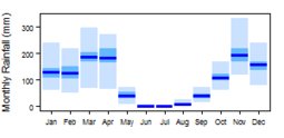
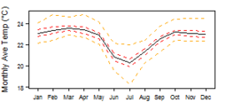
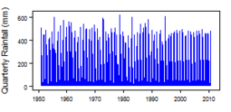
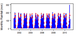
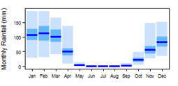
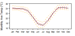
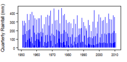
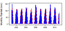
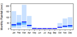
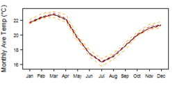
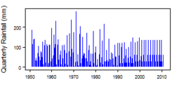
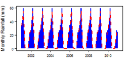
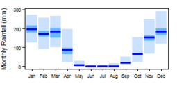
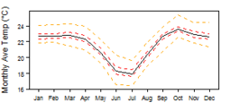
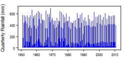
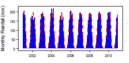
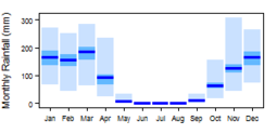
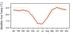
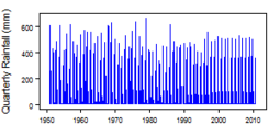
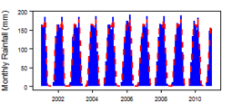
[[File:Angola_Aw_pre_Monthly.png| 255x124px| Average monthly precipitation showing minimum and maximum (light blue), 25th and 75th percentile (blue), and median (dark blue) rainfall / Precipitação mensal média mostrando precipitação mínima e máxima (azul claro), 25º e 75º percentil (azul) e mediana (azul escuro)]] [[File:Angola_Aw_tmp_Monthly.png| 255x124px| Average monthly temperature showing minimum and maximum (orange), 25th and 75th percentile (red), and median (black) temperature / Temperatura mensal média mostrando o mínimo e o máximo (laranja), o percentil 25 e 75 (vermelho) e a temperatura média (preta)]] [[File:Angola_Aw_pre_Qts.png | 255x124px | Quarterly precipitation over the period 1950-2012 / Precipitação trimestral durante o período 1950-2012]] [[File:Angola_Aw_pre_Mts.png|255x124px | Monthly precipitation (blue) over the period 2000-2012 compared with the long term monthly average (red) / Precipitação mensal (azul) no período 2000-2012 em comparação com a média mensal de longo prazo (vermelho)]] | |||
=== Climate for BSh region (Arid Steppe (hot)) / Clima para a região BSh (estepe árido (quente))=== | |||
[[File:Angola_BSh_pre_Monthly.png| 255x124px| Average monthly precipitation showing minimum and maximum (light blue), 25th and 75th percentile (blue), and median (dark blue) rainfall / Precipitação mensal média mostrando precipitação mínima e máxima (azul claro), 25º e 75º percentil (azul) e mediana (azul escuro)]] [[File:Angola_BSh_tmp_Monthly.png| 255x124px| Average monthly temperature showing minimum and maximum (orange), 25th and 75th percentile (red), and median (black) temperature / Temperatura mensal média mostrando o mínimo e o máximo (laranja), o percentil 25 e 75 (vermelho) e a temperatura média (preta)]] [[File:Angola_BSh_pre_Qts.png | 255x124px | Quarterly precipitation over the period 1950-2012 / Precipitação trimestral durante o período 1950-2012]] [[File:Angola_BSh_pre_Mts.png|255x124px | Monthly precipitation (blue) over the period 2000-2012 compared with the long term monthly average (red) / Precipitação mensal (azul) no período 2000-2012 em comparação com a média mensal de longo prazo (vermelho)]] | |||
=== Climate for BWh region (Arid Desert (hot)) / Clima para a região BWh (Deserto árido (quente))=== | |||
[[File:Angola_BWh_pre_Monthly.png| 255x124px| Average monthly precipitation showing minimum and maximum (light blue), 25th and 75th percentile (blue), and median (dark blue) rainfall / Precipitação mensal média mostrando precipitação mínima e máxima (azul claro), 25º e 75º percentil (azul) e mediana (azul escuro)]] [[File:Angola_BWh_tmp_Monthly.png| 255x124px| Average monthly temperature showing minimum and maximum (orange), 25th and 75th percentile (red), and median (black) temperature / Temperatura mensal média mostrando o mínimo e o máximo (laranja), o percentil 25 e 75 (vermelho) e a temperatura média (preta)]] [[File:Angola_BWh_pre_Qts.png | 255x124px | Quarterly precipitation over the period 1950-2012 / Precipitação trimestral durante o período 1950-2012]] [[File:Angola_BWh_pre_Mts.png|255x124px | Monthly precipitation (blue) over the period 2000-2012 compared with the long term monthly average (red) / Precipitação mensal (azul) no período 2000-2012 em comparação com a média mensal de longo prazo (vermelho)]] | |||
=== Climate for Cwa region (Temperate with dry winter (hot summer)) / Clima para a região de Cwa (Temperado com inverno seco (verão quente))=== | |||
[[File:Angola_Cwa_pre_Monthly.png| 255x124px| Average monthly precipitation showing minimum and maximum (light blue), 25th and 75th percentile (blue), and median (dark blue) rainfall / Precipitação mensal média mostrando precipitação mínima e máxima (azul claro), 25º e 75º percentil (azul) e mediana (azul escuro)]] [[File:Angola_Cwa_tmp_Monthly.png| 255x124px| Average monthly temperature showing minimum and maximum (orange), 25th and 75th percentile (red), and median (black) temperature / Temperatura mensal média mostrando o mínimo e o máximo (laranja), o percentil 25 e 75 (vermelho) e a temperatura média (preta)]] [[File:Angola_Cwa_pre_Qts.png | 255x124px | Quarterly precipitation over the period 1950-2012 / Precipitação trimestral durante o período 1950-2012]] [[File:Angola_Cwa_pre_Mts.png|255x124px | Monthly precipitation (blue) over the period 2000-2012 compared with the long term monthly average (red) / Precipitação mensal (azul) no período 2000-2012 em comparação com a média mensal de longo prazo (vermelho)]] | |||
=== Climate for Cwb region (Temperate with dry winter (warm summer)) / Clima para a região Cwb (Temperado com inverno seco (verão quente))=== | |||
[[File:Angola_Cwb_pre_Monthly.png| 255x124px| Average monthly precipitation showing minimum and maximum (light blue), 25th and 75th percentile (blue), and median (dark blue) rainfall / Precipitação mensal média mostrando precipitação mínima e máxima (azul claro), 25º e 75º percentil (azul) e mediana (azul escuro)]] [[File:Angola_Cwb_tmp_Monthly.png| 255x124px| Average monthly temperature showing minimum and maximum (orange), 25th and 75th percentile (red), and median (black) temperature / Temperatura mensal média mostrando o mínimo e o máximo (laranja), o percentil 25 e 75 (vermelho) e a temperatura média (preta)]] [[File:Angola_Cwb_pre_Qts.png | 255x124px | Quarterly precipitation over the period 1950-2012 / Precipitação trimestral durante o período 1950-2012]] [[File:Angola_Cwb_pre_Mts.png|255x124px | Monthly precipitation (blue) over the period 2000-2012 compared with the long term monthly average (red) / Precipitação mensal (azul) no período 2000-2012 em comparação com a média mensal de longo prazo (vermelho)]] | |||
<!-- PLEASE DO NOT DELETE BELOW THIS LINE --> | |||
[[Category:Africa Groundwater Atlas]] | |||
[[Category:Climate]] | |||
Latest revision as of 09:54, 15 February 2018
Africa Groundwater Atlas >> Hydrogeology by country >> Hydrogeology of Angola >> Climate of Angola
Africa Groundwater Atlas >> Hidrogeologia por país >> Hidrogeologia de Angola >> Clima de Angola
Climate Zones / Zonas Climáticas
These maps and graphs were developed from the CRU TS 3.21 dataset produced by the Climatic Research Unit at the University of East Anglia, UK. For more information see the climate resource page.
Estes mapas e gráficos foram desenvolvidos a partir da base de dados CRU TS 3.21 produzida pela Unidade de Investigação sobre o Clima da Universidade de East Anglia no Reino Unido. Para mais informação sobre os conjuntos de dados usados para criar estes mapas e gráficos, consulte a página de recursos sobre o clima (em inglês).
Climate for Aw region (Tropical Savannah) / Clima para a região Aw (Savana Tropical)
Climate for BSh region (Arid Steppe (hot)) / Clima para a região BSh (estepe árido (quente))
Climate for BWh region (Arid Desert (hot)) / Clima para a região BWh (Deserto árido (quente))
Climate for Cwa region (Temperate with dry winter (hot summer)) / Clima para a região de Cwa (Temperado com inverno seco (verão quente))

